Last year I went for a long weekend in Garlieston which is a small fishing village in Scotland. Before I went I checked out the Ordnance Survey maps to check what was there, I was pleased to see there had once been a railway there so I set out to find where it had been and to see what was left. I will start at the station I finished by on the main line and work back to the village.
This was Millisle station or Millisle for Garlieston as it was known it was on the Port Patrick & Wigtownshire Joint Railway.
I found this photo on the Internet and it show the station when it was in use.
 |
This view shows the old station and to the right a line of trees where the railway ran
It would have gone across the bridge here
The bridge deck has been removed to allow the heavy lorries we have now to go through
You can see the line of the railway here as it runs to Whithorn the next station.
Not far from the old road bridge is this one over a burn
The bridge deck is still in good condition though the parapets are in a bad state
I walked along the adjoining field to get a photo of the bridge and after some effort climbed the embankment to get to the old rail bed. I was surprised how clear it was
Though mostly covered with long grass
I followed it back to the road bridge and climbed down a path which at one time was the access for the rail workers but now a footpath though on the occasion I was there it was closed off.
Somewhere around here the link came from the direction in front from the station
Crossing around here past the entrance to the church you can see over on the right.
Then the line went off towards Garlieston in the direction I am looking. A road parallels it and you can see fence posts still in place.
The old railway is over to the left of this photo
Just outside Garlieston you can see this house which was the old crossing house. I went and had a chat with the owner and they told me all about it and showed
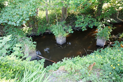
me these pillars in the burn nearby, the railway had turned towards the port and crossed the burn here
The bridge pillars were still there even if the bridge was not
I'm stood where the railway would have come to cross the road
and gone somewhere past the tree you see.
The railway crossed this burn nearby but no sign is there of where it went
Though you can make out it went along to the right where the trees are by this estate in Garlieston
And through this entrance which lead to the wood mill , the wall has been restored so well it's hard to make out where the railway ran
Though it was obvious it ran here which I though would have been the Goods Station as you can see from the map below. The caravan club now owns site and nothing remains of station that was once there.
The line then ran on across the road here in the photo
and along to the left of the road here
To end round here where it looks like the station would have been. A few buildings from the era remain though again any remnants of the station have now gone. I thought it was an interesting little walk to see what was left though I feel it is a shame that we have lost such history.


