The blog is more of an in depth version of my other blog Spuds Daily Photo. I am a bit of a Rural Explorer or as someone on a forum I visit called himself once “Wandering Picture Taker". There is so much out there in the countryside that is over looked and I would like to share with you what is around many from places my wife & I visit.
The Cholsey to Wallingford Railway started live in 1866 originally meaning to go as far as Watlington then onto Chinnor where it would meet the main line again. It stopped at Wallingford due to financial problems and was sold to the GWR. In the end there was a railway to Watlington from Chinnor but that closed in 1960. The Cholsey to Wallingford section closed to passenger traffic in 1959 and finally closed for goods in 1981. A preservation society was formed and took the line over in 1986 when the first trains were run. I thought it would be a good idea to show how the line looks the present day.
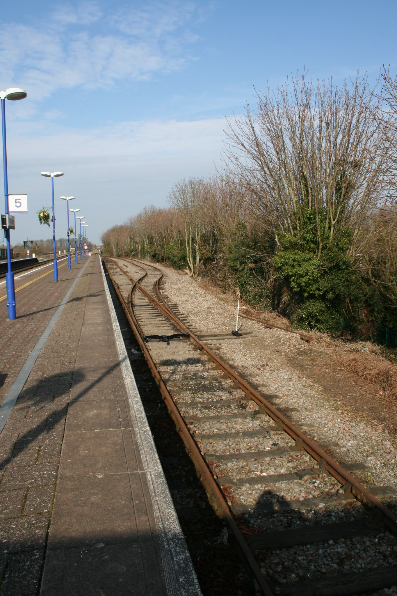
The Bay Platform at Cholsey Station is where you find the start of the line. From memory it has changed little in all the years I have been going to the station
The line runs out West direction before turning off to the right
As you can see from the train coming into the station here
Around the area where the bend is there used to be points that connected the branch to the main line
This old photo I sourced from the Cornwall Railway Society the photo was taken by David Ward. It was the last time a BR train would use the branch line.
This photo is by Roger Joanes and was taken on 17-04-1959. You can see the old signal box that was on platforms 2&3 over on the far right. The carriage in the bay is having boxes loaded on
This photo was taken by the Late Ben Brooksbank of a engine at the bay with passengers getting on, it was taken in the late 1950's
I took this photo in June 2012 at the time I was getting a shot of the engine and carriages in the Bay when this Intercity train came past a lot slower than they normally do on the local side of the track like it was paying homage to the steam train
Excitement with the City of Truro visiting
City of Truro on it's way to Wallingford
This is where the line turns right from the station on it's way to Wallingford, the main line can be seen in the distance
The last photo was zoomed in from a good distance from the main line. The photos were taken in 2008 and it is not something I would do but as kids we did go up here all the time and no doubt they still do.
This is a nice view of the bunk taken in 1968 by Martin Tester off Geograph, it was taken from the entrance of the Bullshole tunnel towards the Bullshole. The gate is still there but very deteriorated and the view is obscured by shrubbery and trees
Another view taken by Frank Dumbleton showing the train on the bend with St Mary just to the left
Walking North a little you can see where the line turns a little more right around the village.
As you come around the bend onto the straight near the church the next thing you will see is Bunk Arch which you will go under. The photo was taken a long time ago and on the left you will see a gate with another on the opposite side on the right. This was to allow the farmer to take the animals across the track to the field on the other side. Part was sold off to allow the New school to be built the other part of the field was given to the village for the Queens Jubilee and is known now as Jubilee Field. Not much remains to tell you there were gates there now. This section of the line is where the Royal Train was stabled overnight on occasions. To my right out of sight were two Electrical boxes, one was put in by the GPO for a telephone connection. There were no mobiles back then.
This is the gate you can see with Jubilee on the far side, the school is over to the left
Bunk Arch from the church field, there school nature reserve is over right hand side
The school allowed me to go in there to get a few photo's and is where you can see this Great Western Boundary Marker Boundary. There is another on the main line where the old Moulsford Station used to be
This photo of an Auto train coming from the arch was taken by Martin Tester on Geograph
He must have turned to the left after to get this shot with St Mary in the background. Back in 1968 when the photos were taken this was a field but a few years later the school was built nearby and this area became the playing fields
A different view of the train in Colour taken by Frank Dumbleton from St Mary's church tower.
This view of the line is taken from the bridge we call Bunk arch the last two photos were taken out of sight to the left. From the bridge you
can see all the way to where the bed is which is a little past the
hedge line across the centre of the photo. Many years ago I was told a story by an old fireman who worked on steam trains. He told me that the Royal train had been stabled up the Bunk one day in 1953. At first I thought this a tail but then I found a reference to this in the history on Cholsey with a photo that shows the Royal train with two engines pulling away towards the main line. Around 50 people were stood on this bridge to witness the train which was stabled around here, if you look at the colour photo by Frank Dumbleton you will notice a white box to the left of the tree, that was the GPO connection point for the phone on the Royal Train so they could keep in touch with the Government. It happened quite a few times after that though getting on the station to see them would have been a problem with all the police around.
Looking the opposite way towards Wallingford the line bends a little to the right past the sewage works
This is what it looks like from the other side with a steam train coming through
Quite imposing when your close to the fence
This is a crossing that is still in use in the field along from the bridge
The next place you see along the line is the sewage works which was built round the 1950s to cope with the waste from Cholsey & Wallingford
Old signalling equipment stored on the side of the railway
You follow the footpath if your not on the train
The next place you will come to along the line is this old level crossing
The bottom sign is an old British Rail warning telling you that you could be fined £200 pounds, Now if you did on the main line you are looking at been lighter of £1000 for your trouble
List along from the crossing are some end buffers stored for later use
as you are on the crossing you can looking back up the line towards Cholsey the former Hillgreen Farm can bee seen over on the right
Looking the other way towards Wallingford and Coxes farm the next place you pass
Further along you pass more rails stored on the side
Another old sign with a W on it not sure what that means
Near Coxes Farm is an old Workmen's Hut, trashed long ago by the local kids
Bogey wheels lay beside it forgotten about and becoming covered in weeds
I'm not saying you should go wandering around along the railway but the fence is broke in a lot of places and it there are not trains running it is normally safe enough if you take care, you can see some really old railway ties
The oldest one I spotted was 1903
Further along you can see another workman's hut in better condition
A little way along the track after the hut you will come to the level crossing near Hithercroft Farm
This was the lever crossing for farm traffic and still is for the private residence there now though the track is cut short due to the By-Pass in the distance, it used to go all the way to Winterbrook. That part now is a footpath
The old warning signs are still there and the gates left open
The line looking back to Cholsey
and towards Wallingford with the farm track on the right, the By-Pass in the distance
Zoomed in you can see a van going across it.
Now this photo was taken in 1993 when the By-Pass had opened, the gates are closing
Because one of the first trains was coming through
This was looking down from the road cutting back in 1992 towards where the crossing would be
Just before the road and crossing were opened in 1993
The level crossing with little traffic on it back in 2008
Looking back towards the farm crossing
This way looks towards Wallingford. The footpath does not follow the line on this section but it is less than a mile to the station that is there now.
Zooming in you can see the tracks bend to the left
Where it eventually joins up with the current station
Another photo taken in 1968 by Martin Tester was most likely taken near where the station is now
Old Moor bridge would be behind him.
Which is here at Hithercroft. The station as you see is more or less just a platform they have built along side the end of the railway. the intention to built a more substation place in the future.
This is what the station used to look like and was about half a mile further along the track I found the on the British Water Towers Appreciation Society blog and do not have a photographers name.
This is the current platform with the new canopy being erected
It will make a welcome addition to the facilities they have
This is where you start on your visit
After going through this gate
Before you got there you would have gone under this bridge called Old Moor Bridge, your looking towards the Creamery the current station is around the area of the photgrapher who is R.M.Cassery the photo was scanned from the book The Wallingford Branch
First of all the new station is where the track runs off the map the road you see ran over the bridge shown, the part over to the left of it was a creamery which the railway served as well
This place taken in the 1960's by Anthony Eward Smilth. Now I suspect the bridge had gone by then as the windows in the building are broken and there is a road sign telling you it is Borough Avenue which is built on the old railway. The bridge would have been somewhere around near or behind the photographer.
This map shows the station layout/ The allotment gardens are now a housing estate and Mill Brook runs under it all as a culvert. Not sure they would get away with that now but back the greedy developers and councils did not have any rules so ran riot.
Wallingford station you can see a Victorian water tower that is no longer there nor are the gas tanks all you can see is a concrete water tower now. Now I would think the brick tower would have had a preservation order slapped on it. The photo was sourced off the internet but may have been M.E.J.Deane taken around the 1950's
This one at Wallingford was taken by the late Ben Brooksbank on Geograph
This photo by Roger Joanes was taken in 1959
A few years later it was closed this photo was taken in the 1960's, I thing a few years after closing
Some time during the between the 1960 to 1970 the station site was built on and is now a housing estate.
The photo by Nigel Thomson on Geograph shows the area the station once stood, I doubt any one living along here realises that.
It would have been around here that that Old Moor Bridge once stood
Borough road is to the right and is built on the old line that went to the station, The creamery would have been to the left
I'm stood around where the railway would have gone under Old Moor bridge
There used to be a set of lock up garages here but the council decided housing was needed more so the house owners who used them now have to park else where, the line of houses more or less follows the old track line as it went to the station. The road over to the right is called Old Moor Close named after the bridge which was where I am standing
The station today with the Polar Express at the buffers
In the past the Cholsey & Wallingford Railway has been through some rough times and I think financially they struggle at times but credit to them they still keep going even though they are small in comparison to other preserved railways like Didcot Railway Centre In some ways I feel it is a shame they were not affiliated together the Didcot could run some of the trains they have there along the line. I feel Wallingford Station and sidings should never have been sold off the whole lot could have been run as a heritage railway. Instead BR just wanted to off load it and greedy town council where only too happy to have a new housing estate built on the site and allotments. Old Moor Bridge and the station were quickly demolished in 1969 and the result is what is around us now. This year it must have been a real struggle with the pandemic we are going through as no trains have run but I notice a canopy now being built that was saved from Madenhead, this will make the station quite an attraction. I will be getting some more photos to finish this blog off and some of the station as it is now.
Before I go you will notice some of the photos were taken on the
track these were taken for reference to show how the line looks, it is
not some thing I advocate anyone to do especially on the main like where
you be given a hefty fine for doing so. The fence along the footpath
following the railway is broken in many places and there are a couple of
crossings you can look along the line from but all I say is take great
care especially when the trains run at weekends and holidays.
That's the Cholsey & Wallingford Railway. Just over two miles of track with some in my mind uninspiring views around the local countryside spoiled now by a gravel works near the bypass and housing estates springing up all over the place and no doubt some greedy developer would like to build on the part the station stands now, lets hope it never happens.
The Youtube video shows what it was like to ride the train back in 1968


 This was looking down from the road cutting back in 1992 towards where the crossing would be


